Headed out to the VROC rally in Cortez early Thursday. Light rain that ended as I was leaving the valley. Kind of cool, so I thought about putting on my heated jacket liner. After all, I had wired the Vstrom for the liner. As I inventoried my various packing locations in my head, I quickly realized there was no liner, I had not packed it. Oh well, I'm on the road.
I took I-15 through Provo as they were taking the overnight construction barriers down, so it was smooth sailing down to Hwy 6. I only took 6 to Thistle before turning south to Fairview. It was cool enough to warrant a coffee stop in Fairview, where a local started chatting about the bike and my trip. I mentioned that I had wanted to take Miller Flat road through the backcountry but the snow on the mountains would probably stop that plan.
"Oh no," he said, "it's fine, I was on it last weekend." Perfect, I thanked him and set out. Up Eccles canyon through some nice twisties.
 There was snow on top of the pass, but I knew I would be dropping a little lower before taking the dirt road.
The road was in great shape, deadwood that fell through the winter was cleared and the road was ready to go. I stopped at a pretty mountain lake to take a few pictures.

Then the road dropped down through the forest to Joe's Valley Reservoir, total ride about 21 miles of dirt.

I was last here about 10 years ago on a paleontology trip, didn't remember the nice canyon road that went from Castle Dale to the dam.

As I came into town, I saw an assortment of old equipment, but one piece caught my eye. an indulgent grandfather (are there any other kind?) had apparently made a swing from one of the old cranes. Click on the picture to blow it up to see his handiwork.

done with taking that picture, I continued on. As I was in 20 mph traffic in the middle of town, all 3 vehicles came to a stop for a much more important event. Sheep drive. the dogs were working hard to keep the sheep moving through the traffic. The cowboys (YOU call them "sheep boys" - there is a long history in the west of trouble between sheep and cow) kept pushing and whistling, keeping everything moving and making sure the dogs chased the stragglers.

Check out the reflection in my rear view mirror below, this was a big drive.

The drive only held me up about 15 minutes. I continued through town and into the desert. Broke my own rule about not passing gas stations in the desert, and nearly had my comeuppance on the other side of the trip.
My destination was the Wedge overlook on the San Rafael Swell. I had not been to this beautiful area before. Standing on the edge of the Wedge Overlook, 5 or 6 cliff swallows began flying fast circles around me. They had been traveling up and down the cliff face, either mating or eating, I think I just happened to be there. Whatever the reason, I could hear them flying through the air around me! They sounded like the tie fighters from Star Wars as they whooshed around my head. the river in the picture below is the San Rafael, this area is known as the Little Grand Canyon of the San Rafael.
 Just as at the North Rim of the Grand Canyon, there is a sandstone fin you can walk out on to view the canyon. Being a Utah area and not a National Park, this fin has no guardrails or fences with a 600 foot drop on each side. We lose a few tourists every year and someone invariably calls for more protection, but no one much listens. When I hear these things, I think of Wallace Stegner's explanation that humans needed not only wilderness to visit, but also to know there were wild places they could visit, even if they never did.
After leaving the overlook, I continued to the south down Buckhorn Wash. This wash is known for a petroglyph panel dating back at least 2000 years, to the Barrier Canyon era. A moving place indeed. About 25 miles off Interstate 70 at an unmarked ranch exit. I wonder how many people know they are a short 50 mile drive on a good dirt road from a national treasure? Probably best for the rock art panel that they don't know.


As the wash exits the swell, the road crosses the San Rafael river. This suspension bridge was completed in 1937 and a local exhibit shows the surrounding flats full of cars that brought people to the opening of this area, including the sitting governor.

This tree has been here almost as long as the bridge.

As I finished the ride and headed on I-70 east to Green River, the gas gauge began flashing all sots of combinations to let me know I was low on fuel. I pulled into the gas station but wanted to oil my dusty chain first. While I was doing so, a bright yellow beetle dropped from somewhere in the frame onto the parking lot and calmly walked away.
Continuing on to Moab, I had time to take in Dead Horse Point and Chimney Rock. Tom Cruise fans will remember the opening scene from Mission impossible. I think this is where he was supposed to be hanging.

Dead Horse Point has a nice view of the Colorado before it joins the Green.

The dirt road on the bench below is part of the White Rim Trail. I'd like to ride that someday.

Continuing into Moab, I stayed at the Bowen Motel near downtown. A quick walk to everywhere, older but clean. And they had a bike wash! A small area walled off with a drain and a hose and a ready supply of clean rags at hand. They told me about it as soon as I checked in (maybe they could see how dusty the V-strom was?).
dinner at Miguels, looks much smaller than it is, with very good food, then off to an early sleep.
The waiter at Miguel's notice me looking at my map book and suggested a circumnavigation of the Abajo Mountains west of Monticello and Blanding, Utah. Having done so well with local advice the previous day, I thought, "why not?"
I took the turnoff for Newspaper Rock, one I had meant to take but always passed when I have been in the area. I really glad I stopped this time.

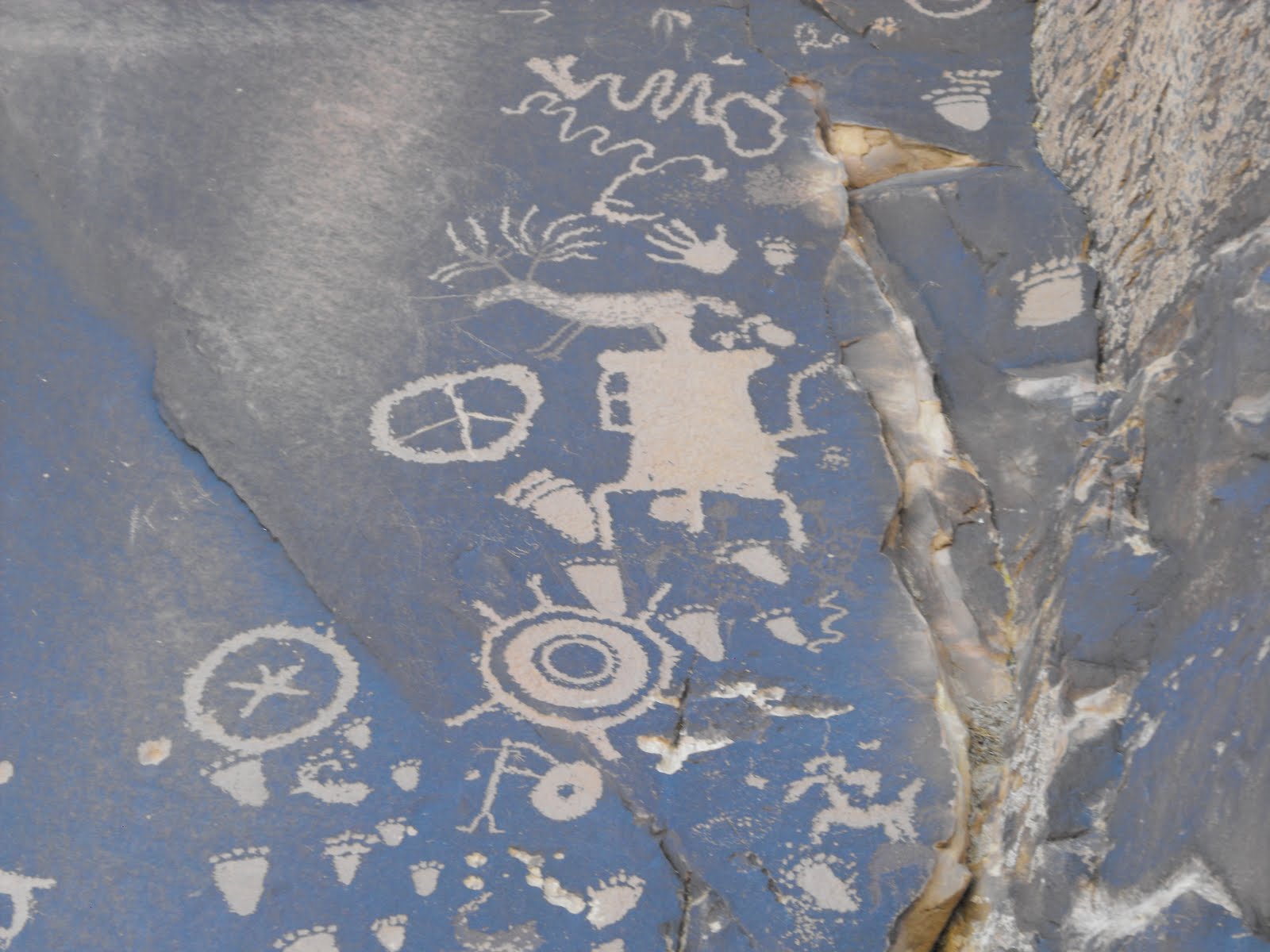 There is always mystery about the meaning of the petroglyphs, but it looks to me like an early hunting blog.
Leaving the morning visit at Newspaper Rock, I traveled down this beautiful valley.
 At the turn was an old uranium mine, what a scenic location!
Rounding a bend, I had to stop to survey the stream bed, but it looked okay to ford. Made it across just fine, but tipped the bike as I stopped on the other side. no harm done and I picked it up and continued on my way.
 A pickup passed as I stopped to take a picture down this canyon. You almost have to click on the picture to get an idea of how magnificent this valley is.
 The road began to climb, and soon I was on the bench above the valley.
 Below, you can see the road snaking around the canyon edge as it did most of the way.

Being spring time with recent rains, the grass was long and lush. That is the Abajo Mountains in the background.


I finally turned around when I arrived at the road below. I parked the bike where I could still turn around and walked to see what the road did. The road got narrower and tougher. I got out of there. I realized about this time that I was halfway through my mileage range (figuring on a good safety margin) but only about a quarter to a third around the mountains. Also, I began to notice the darkening sky.
 I decided to take a well-graded road to the valley to take a quicker route out of there. The well-graded part only lasted to the first decline, but I went anyway.
 I took a much better valley road back the way I had come, but it too began to deteriorate. I crossed a small stream, rode about 100 yards and the road crossed another small stream. Except that I couldn't see where the road came out on the other side. I walked the creek to see how much riding I would have to do in the stream bed but after 50 or 60 feet I gave up when I could not see an exit. I would have to turn around and go back up the hill I had come down to retrace my route to the pavement.
When I got back to the bike, I had a hitchhiker.
 this snake had crawled into my rear tire, I think because he smelled the water from the crossing. I rattled a stick at him to move him on his way and he climbed into the chain and chain guard.
 I figured if I moved away from the bike, he would drop off the frame and leave, but as he did so he apparently smelled the water on the front rim too!
 Finally tiring of the paparazzi, he moved on.
 I still had to cross the creek I had crossed as I entered this area. The deep side was on the near side and I was over confident. The bike went most of the way across, but went down in the water. The picture below is after I Quickly got it back up and closed the saddlebag that had fallen open. I was soaked and it was cool, but nothing a little riding wouldn't dry off.
Deciding I had enough adventure for one day, I stopped in Monticello for gas and a Subway sandwich and continued to Cortez to see some old friends.
Great ride! You're one confident guy to do that alone! GBG Cranky
ReplyDeleteGreat post, Mike!
ReplyDeleteExcellent photos and write up Mike. What berautiful country.
ReplyDeleteSage